How Houston Aerial Photography is Changing the Way We Capture the City?
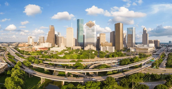
The way we capture a city’s landscape is constantly growing. In Houston, aerial photography offers a fresh perspective, changing how we see and understand the city. From stunning images of its growing skyline to detailed snapshots of the surrounding landscapes, aerial photography is now at the forefront of how we document urban development and environmental changes.
The Impact of Aerial Photography on Urban Development
Aerial photography has proven to be an invaluable tool for urban planners and developers. It provides a bird’s-eye view of the city’s infrastructure and growth, making it easier to visualize land use, zoning, and potential areas for development. This approach allows city planners to make informed decisions that help shape Houston’s aerial photography growth in a way that benefits both businesses and residents.
Using aerial photography, developers can easily analyze areas, pinpointing opportunities for new constructions or renovations. These detailed images allow planners to track Houston’s rapid growth and plan for the future effectively.
How Aerial Photography Supports Environmental Monitoring?
With the ability to capture expansive views of green spaces, water bodies, and other natural resources, aerial photography helps track environmental changes over time. This is crucial for assessing how urban sprawl impacts local ecosystems. Photographers often capture images of parks, rivers, and the surrounding nature reserves, helping environmentalists and the city monitor these spaces. The ability to quickly assess areas from above helps local authorities understand how urbanization is affecting Houston’s natural beauty and resources.
The Role of Technology in Advancing Aerial Photography
While traditional photography methods required large planes or helicopters, drones have made capturing aerial images more affordable and practical. With drones, photographers can now reach places that were once difficult or costly to access. These technological advancements allow for more frequent and detailed aerial images of a city. It’s also easier to share these images with the public, giving residents and businesses a clear view of developments in real-time. Drones have also lowered the cost of aerial photography, allowing a broader range of industries to benefit from this innovative tool.
The Future of Aerial Photography
With drones becoming even more advanced and affordable, more industries will rely on aerial images for their day-to-day operations. This will enhance the ability to monitor the city’s growth, assess environmental impact, and respond quickly to emergencies. As the demand for high-quality aerial images continues to grow, we can expect to see even more creative ways to use these images. In the future, aerial photography may become a standard practice for real estate, construction, and urban planning in Houston, making capturing the city from a fresh perspective easier.
Conclusion
In Houston, aerial photography has transformed the way we capture and understand the city. It provides invaluable insights into urban development, environmental monitoring, and disaster management. With advancements in technology, aerial photography has become more accessible, allowing a wider range of industries to benefit from it. As we move forward, it’s clear that aerial photography will continue to shape how we see and interact with the city. Whether for planning, monitoring, or responding to emergencies, aerial photography will remain a vital tool in capturing the ever-evolving landscape of Houston.